United States in Powerlines
.flickr-photo { border: none } .flickr-yourcomment { } .flickr-frame { text-align: left; padding: 3px; } .flickr-caption { font-size: 0.8em; margin-top: 0px; }
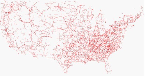
The systems of the distribution of power are depicted in this map from the Open Street Map Project. If you are in New York City on the weekend of June 28th and 29th there is a mapping party.
Previously, all the roads in the United States
tags:map opendtreetmap OSM power grid
«previously ikea comes to brooklyn
RFIDs are beautiful next»
Written by admin (contact).
It was written on June 19th, 2008 at 10:54 am
Filed in the Category cool, geo, map, mapping, orphan