Tagged with map
VFRMAP
Posted April 23rd, 2012 at 11:47 am. There are 0 comments.


London-on-Sea
Posted December 13th, 2010 at 12:52 pm. There are 0 comments.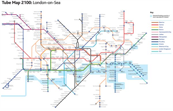
Practical Action has a slightly modified London tube map showing the impact of rising sea levels predicted for the the year 2100.
via bldgblog
superbowl twitter timeline on nyt.com
Posted February 3rd, 2009 at 11:34 am. There are 0 comments.
Wonderful map + timeline showing most popular ‘tweets’ during the superbowl. You can look at all ‘tweets’ or seperate categories such as ads (Cash4Gold and GoDaddy being ones I personally contributed too, in as much as I thought they were aweful) or the ever useful emoticon map.

Walk the Line
Posted November 7th, 2008 at 10:45 pm. There are 0 comments.


I printed my portrait on various maps. Then I started to orientate the maps following the lines on my face. On my arm I carried a satellite recorder (GPS) drawing the path that I walked.
Artist Antti Laitinen Walk the Line Project
undersea cables
Posted June 27th, 2008 at 5:01 pm. There are 0 comments.
The undersea cable that make up much of the long haul data transfer on the internets. This map from the Guardian details the incident where a cable was damaged by a ships anchored and internet traffic was significantly affected. Hacker Tourist’s may be interested in the story surrounding many of these cables as reflected by Neal Stephenson in Wired magazine a few years ago.
update: dropped in michael surtee’s weekley link drop on july 4 2008
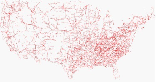
United States in Powerlines
Posted June 19th, 2008 at 10:54 am. There are 0 comments..flickr-photo { border: none } .flickr-yourcomment { } .flickr-frame { text-align: left; padding: 3px; } .flickr-caption { font-size: 0.8em; margin-top: 0px; }
[ iamtheweather powered by Wordpress And is definitely Not Plastic Bag ]