In the Category map
street view coverage maps
Posted December 9th, 2008 at 6:07 pm. There are 0 comments.Google updated Street View in the US today and have expanded the coverage quite a bit. What used to be a series of small puffy blue clouds covering mostly metropolitan areas has now become are sea of blue covering much of the nation.

After

Before
Unfinished Swan
Posted October 30th, 2008 at 11:51 am. There are 0 comments.
The Unfinished Swan – Tech Demo 9/2008 from Ian Dallas on Vimeo.
The understated simplicity of this navigation, feeling around in the dark so to speak, is very compelling to me.
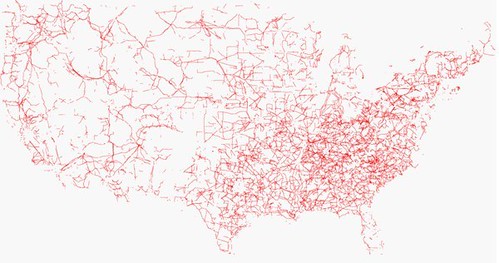
United States in Powerlines
Posted June 19th, 2008 at 10:54 am. There are 0 comments..flickr-photo { border: none } .flickr-yourcomment { } .flickr-frame { text-align: left; padding: 3px; } .flickr-caption { font-size: 0.8em; margin-top: 0px; }
follow the red line navigation
Posted December 19th, 2007 at 9:38 am. There are 0 comments.
Virtual Cable technology that draws route information in an augmented reality display. The 3 dimensional display is created with lasers and mirrors (didn’t fully read that section) and is generated from standard route information output by numerous GPS and SatNav systems available today. The remarkable part about it is the simplicity of the system. “Follow the red line around until we tell you to stop.” The danger may be, as we have seen before, that the information is followed blindly, although keeping ones eyes on the road, and slightly above it, may be better for safety than trying to focus on small map screens, or to decipher the robo-voice directions to bear left in point-five-two miles.
[ iamtheweather powered by Wordpress And is definitely Not Plastic Bag ]
