In the Category information
The Hand Drawn Map Association
Posted June 26th, 2009 at 1:47 pm. There are 0 comments.
The Hand Drawn Map Association is an ongoing archive of user submitted maps and other interesting diagrams created by hand. There are 150 maps submitted already including some lovely map collections.
Our current collection features a set of maps created by John Hutchison exploring his relationship to the 50 states in the US. The collection starts with a map representing all of the US states. Each successive map in the collection reveals a different set of states based on increasingly limiting criteria until we are left with only 1 state (his least favorite).

Image Credit: John Hutchinson April 29th – “US state I have Visited”
ring roads of the world
Posted May 28th, 2009 at 9:01 am. There are 0 comments.
Ring Roads of the World by Thumb for Rice school of architecture. Houston, where Rice is located, is shown in black. Second largest is Beijing, shown in red. Ring road?
workplace skills of the future
Posted May 16th, 2009 at 12:35 pm. There are 0 comments.In the rapidly approaching future, and increasingly the present, new sets of skills are required to successfully operate within the new work landscapes we are creating for ourselves. My top five from the list of 10 Workplace Skills of the Future
Longbroading
Seeing a much bigger picture; thinking in terms of higher level systems, bigger networks, longer cycles
Open Authorship
Creating content for public modification; the ability to work with massively multiple contributors
Multi-Capitalism
Fluency in working and trading simultaneously with different hybrid capitals, e.g., natural, intellectual, social, financial, virtual
Signal/Noise Management
Filtering meaningful info, patterns, and commonalities from the massively-multiple streams of data and advice
Emergensight
The ability to prepare for and handle surprising results and complexity that come with coordination, cooperation and collaboration on extreme scales
boffin from last.fm
Posted May 15th, 2009 at 8:42 am. There are 0 comments.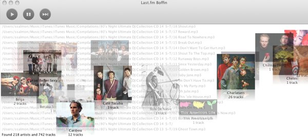
Boffin is last.fm radio for your local music. You aim it at your music collection and it crunches for a bit. While it eats up your music you get a wonderful view of it all, with filename scrolling at warp speed in the background and album covers moving right to left.
This is the nicest possible progress bar an app could have.
When it’s done you get a tag cloud and you can pick the different genres you want to listen to.

today is a
Posted May 12th, 2009 at 11:07 am. There are 0 comments.

todayisa.com checks the weather, news stocks and other mystey stuff to determine is the day is goo, or bad. Also available in json, LOL, boolean or on twitter @todayisa
subway sparklines
Posted May 9th, 2009 at 4:18 pm. There are 0 comments.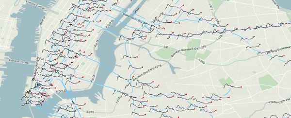
Mike Frumin’s map that show New York City subway ridership between 1905 to 2006 with sparklines for each station. Its great to see sparklines in use on a map, where the detail given by the sparkline is a kind of cartographic detail you can get lost in when looking at a map.
The general idea it that the history of subway ridership tells a story about the history of a neighborhood that is much richer than the overall trend.
classic airline logos
Posted May 6th, 2009 at 11:14 am. There are 5 comments.
Collection from the Museum of Flight.
via onpaperwings
On the Grid
Posted April 30th, 2009 at 7:17 pm. There are 2 comments.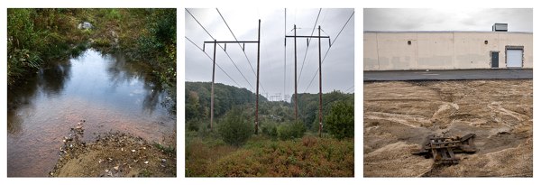
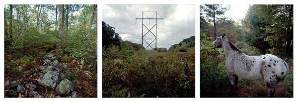
On the Grid is a project documenting the space created by the vast nationwide network of powerlines and the land underneath them. Undeveloped except for the powerlines them selves they carve through the landscape, connected the most rural with the most urban. The shared space, buzzing with the hum of excess electricity, is at times a pristine and beautiful meadow surrounded by forest and others, the uninhabitable tract amongst suburban banality, beautiful in its own right.
On the Grid, a project by Adam Ryder and Brian Rosa, explores the landscape immediately surrounding high-tension electric transmission lines in Rhode Island. Starting near the Ocean State Power facility in Burnllville, Ryder and Rosa spent several days walking along various sites of this arterial infrastructure. Sites were chosen though surveying publicly available aerial photographs and land use maps, and all photos were geotagged with handheld GPS units. In combining the rigid technical process of digital mapping with the subjective practice of landscape photography, this project explores the state as a collection of differentiated spaces that, though seemingly isolated, are networked.
The resulting photographs showcase the topographical diversity surrounding these structures, whose own narrow terrain remains virtually unchanged throughout their straight, incisive paths. The path of the power lines functions as a rural to urban transect, cutting through farmland and commercial parks, cul-de-sacs and strip malls, used car lots and interstate highways.
As human intervention in the natural landscape sprawls to the most remote areas of the state, our lived space becomes increasingly regulated and our encounters with equivocal territories are especially rare. In more urbanized areas, we lose our relation to places which seem to exist unto themselves, where one can feel alone and unhindered. The ambiguity of the land occupied by high-tension power offers the possibility of experience outside of regulation. Despite being part of an infrastructure that is highly regulated and bureaucratized, the physical space inhabited by these power lines remains easily accessible though its sheer ubiquity. Thus, paradoxically, the realm of power lines seems to exist not only outside of regulation, but also outside of the normative properties of the native landscape. Whereas an area half of a mile away from a high tension line may be densely wooded, the space occupied by the wires will be clear-cut, devoid of trees and exhibiting, at most, low shrubbery and grass. The uniformity of this narrow swath as it cuts through the landscape reveals as much about its own spatial utility as it does of the landscape it bifurcates across the state (and beyond). It is this topographical sameness that makes the power lines amazing sites of contrast against both development and the natural landscape.
On the Grid invites reflection on the blurred relationship between networked technology, the built environment and nature through these buzzing monoliths.
– Website Text (An image on the original website)
They did a nice interview on the NPR show Living on Earth (mp3 link).
Quoting here,
Yeah absolutely, it’s a really unique tract of land that doesn’t have any development on it except for itself. So, it’s kind of, in a way its really pristine and untouched and…virginal, its kind of, kind of like, romantic and magical in that way.
-Adam Ryder
and
What’s really – I think actually awesome, is the best word I can use to say it – what’s really awesome about seeing this parade of power lines through the landscape, especially in rural areas is that we’re kind of seeing these, these tendrils connecting humanity as one large organism and it’s a cool way of looking at us, you know what I mean?
-Adam Ryder
Locate powerline grid infrastructure near you via this previous post
sky, free of charge
Posted April 30th, 2009 at 3:15 pm. There are 0 comments.
Sand Ocean Sky Available 7 Days Free of Charge – Steve Lambert
dead pixel for google earth
Posted April 30th, 2009 at 11:50 am. There are 0 comments.82 x 82 cm burned square, the size of one pixel from an altitude of 1 km.
A real life dead pixel by Helmut Smits. Digital display technologies affecting the real physical world with it’s intentions of affecting the digital representation of the physical world. See also.
[ iamtheweather powered by Wordpress And is definitely Not Plastic Bag ]